Students contribute to AI Research
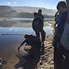
Changing Beaches Research Challenge, Monterey, CA
At the core of the Junior Researcher program is the Changing Beaches Research Challenge that provides middle and high school (grades 8–12) students an opportunity to engage deeply with scientist Dr. Mara Orescanin of the Naval Postgraduate School and contribute in a meaningful way to her research program.
This challenge aims to develop an artificial intelligence (AI) method to detect coastal change using unmanned aerial vehicles (UAVs) and a neural network (deep learning) method for image classification. To test these methods, and to train the neural net through machine learning, Junior Researcher students in grades 8 - 12 will contribute data on water quality, sediment, vegetation, and river location at the Carmel River State Beach, that is known to breach seasonally (in winter months), drastically changing the morphology and water quality.

Year 1 Cohort
We appreciate the dedication of these engaged teachers in our first field season:Rebecca Taylor - Evergreen Valley High School
Carolyn Laymon - Seaside High School
Alex Hofsteen - International School of Monterey
Polly Ficken - East Union High School - Manteca USD
Geoffrey von Saltza - Monterey Academy of Ocean Sciences
Assignments
Scoutlier is used for collection of a comprehensive, high quality data set in the field. Junior Researchers Monterey assignments will be available in the Shared library and linked here in our 2019-2020 field season.
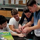
Scientific Progress!
Over 200 students from 5 schools conducted scientific field work to support Machine Learning research. Dr. Orescanin shared initial results and research context in a virtual conference summarized in the video below.
Spring Virtual Conference
Challenge Motivation
Junior Researchers Role
Junior Researcher students will play a critical role in this project by validating (ground truthing) and enriching the remote imagery and GPS data obtained through frequent on-site monitoring of the Carmel River State Beach and lagoon areas, as well as analysis of water samples. Students will also assist in tagging data elements, such as vegetation type and sediment levels in land and aerial images.
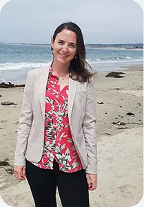
Research Scientist
Dr. Mara OrescaninMara is a Coastal Oceanographer at the Naval Postgraduate School where she advises students, teaches courses, and conducts oceanography research. Her research focuses on coastal physical oceanography relating to exchange between land and sea through rivers, inlets, marshes, and estuaries. She believes in an hands-on approach to teaching and mentoring geared at stimulating active learning and has mentored students at all levels from middle school through graduate school. For more about Mara visit Jason Learning: STEM Role Model and her website This project will be run by faculty at the Naval Postgraduate School.
|
 |
This project is funded by a grant from the Office of Naval Research